THEBESTINSPAIN.ES ≡ Victorian & Edwardian Reels Complement Alimentaire Dublin
  • North America

  • New Brunswick Nova Scotia Map 1890’s

New Brunswick Nova Scotia Map 1890’s

$35.96 $52.85
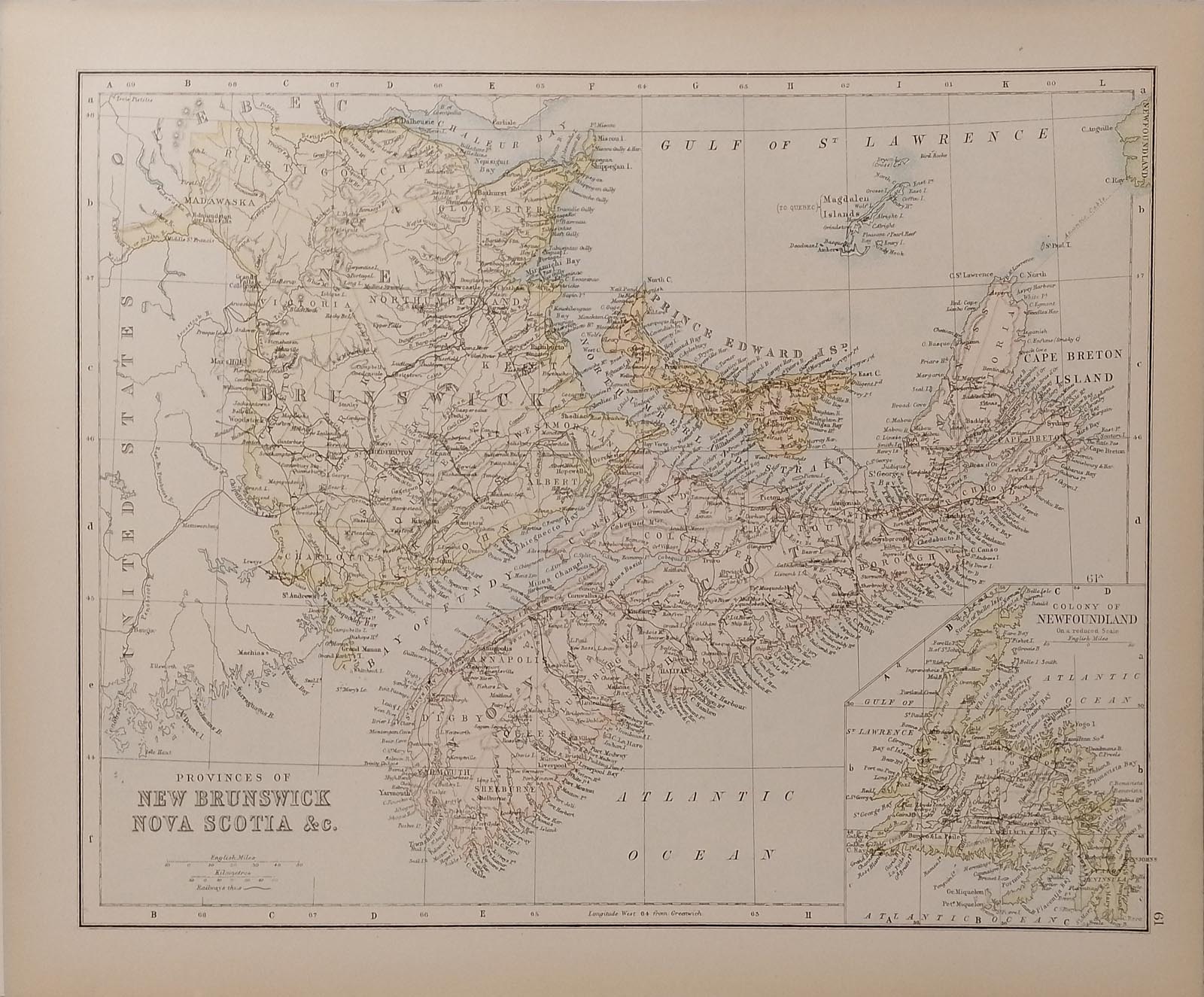
Antique colour map of the provinces of New Brunswick and Nova Scotia, there is also smaller map of the colony of Newfoundland on the bottom right. On the reverse is a map of the USA. The map is in very good condition for age, very clear and vibrant with good margins for framing, paper will show light ageing. The map was originally published as part of Collins Complete Atlas and Gazetteer of the World published in the late 1890’s. Population data from the gazetteer would date the maps circa 1895 to 1897 period. The map measures 23 by 30 cm’s with the overall paper size of 27 by 34 cm’s
North America

North America

  • Building at Sabachtsché 1856 Yucatan Mexico
    $35.1 $42.12
  • Labna 1856 Yucatan Mexico
    $35.1 $57.56
  • Zayi 1856 Yucatan Mexico
    $35.1 $54.05
  • Antique Map West Indies 1890’s
    $35.96 $55.37
  • Yalahao 1856 Yucatan Mexico
    $35.1 $62.48
  • Izamal Gigantic Head 1856 Yucatan
    $35.1 $49.49
  • Antique Map Mexico 1890’s
    $35.96 $71.19
  • New Brunswick Nova Scotia Map 1890’s
    $35.96 $52.85
  • Tuloom Front of the Castillo 1856 Yucatan
    $35.1 $56.16
  • Sabachtsché 1856 Yucatan Mexico
    $26.96 $45.01
  • Ancient Mound Village of Silan 1856 Yucatan
    $35.1 $65.99
  • Teo Callis at Chichen Itza 1856 Antique Print
    $35.1 $48.79
  • Kewick Yucatan Mexico 1856 Print
    $35.1 $49.49
  • Gateway at Labna 1856 Yucatan Mexico
    $35.1 $43.52
  • Tuloom Frederick Calderwood 1856 Yucatan
    $35.1 $60.72
  • Ancient Building Island of Mugeres 1856 Yucatan
    $35.1 $43.17

© 2026 - THEBESTINSPAIN.ES